Kitheronas topoguide
2.5
Kitheronas topoguide
2.5
Mt. Kitheronas topoguide is a digital field guide for hikers and nature lovers.
It includes routes, descriptions and photos for 13 hiking and mountaineering trails which spread throughout Mt. Kitheronas, near Athens, Attica, Greece.
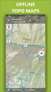
The application offers detailed offline maps and an extensive introduction on geography, geology, the nature and the rich ancient history of Mt. Kitheronas. Special attention is given to the rich flora of the area, with dozen of are plant species described and plotted on the map.
The app offers also a useful list of POIs with a search feature from the map screen.
The trails list includes easy walks, easy and moderate hiking trails and long mountain traverses, of a total length of 118 km.
In the field, the app identifies the nearest adventure, guides you to it and then along it by displaying messages and warnings on every junction or other important location. On each Point of Interest, photos and texts are displayed on the map. If the hiker gets off-trail, the app indicates the shorter way to get back safely.
Also, a navigation feature allows to calculate routes and distances along roads and paths anywhere on the island.
Mt. Kitheronas is also know as Cithaeron or Kithairon.
DISCLAIMER
During track recording, continued use of GPS can dramatically decrease battery life.
It includes routes, descriptions and photos for 13 hiking and mountaineering trails which spread throughout Mt. Kitheronas, near Athens, Attica, Greece.
The application offers detailed offline maps and an extensive introduction on geography, geology, the nature and the rich ancient history of Mt. Kitheronas. Special attention is given to the rich flora of the area, with dozen of are plant species described and plotted on the map.
The app offers also a useful list of POIs with a search feature from the map screen.
The trails list includes easy walks, easy and moderate hiking trails and long mountain traverses, of a total length of 118 km.
In the field, the app identifies the nearest adventure, guides you to it and then along it by displaying messages and warnings on every junction or other important location. On each Point of Interest, photos and texts are displayed on the map. If the hiker gets off-trail, the app indicates the shorter way to get back safely.
Also, a navigation feature allows to calculate routes and distances along roads and paths anywhere on the island.
Mt. Kitheronas is also know as Cithaeron or Kithairon.
DISCLAIMER
During track recording, continued use of GPS can dramatically decrease battery life.


Celkové hodnocení
Sdílet
Souhrnné informace o Kitheronas topoguide
-
Verze programu
2.5 -
Autor
-
Potřeba instalace
ne -
Velikost souboru
14 MB -
Jazyk
- Angličtina ,
- Řečtina
-
Staženo
0× celkem
0× tento měsíc -
Poslední aktualizace
31. 1. 2020