New York Subway & Bus maps
This is a simple app with all you need to know about the subway while enjoying New York City. It features the MOST UPDATED offline subway map. You can zoom in and zoom out as much as you want. As easy as it seems. Get rid of the traditional paper map and enjoy New York City subway from your phone. This is all you need for using NYC's Subway.
This app features
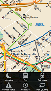
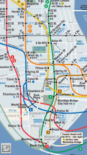
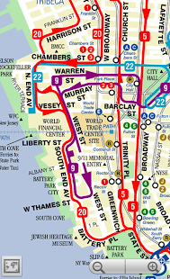
-Subway day and late-night maps of New York City and suburbs.
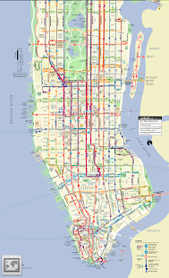
-Bus maps for Brooklyn, Bronx, Queens, Manhattan, Staten Island.
-Railroad and ferry connections.
-Maps are movable to the SD card
-Maps are downloaded the first time you check them and stored on your cache till you update or uninstall. So that you can browse them offline
-Real-time service status from the original MTA agency
-Subway and bus schedules for every single stop
-Trip planner, with point to point directions all over New York City
Bus maps need to be downloaded from the internet the first time you check them. Each of them occupies a few MBs, so they take a while to download. From then on, they'll be available for offline use.
Support for android versions prior to 2.3 has been discontinued.
Send me your suggestions and I'll try to add/fix them.
This app features
-Subway day and late-night maps of New York City and suburbs.
-Bus maps for Brooklyn, Bronx, Queens, Manhattan, Staten Island.
-Railroad and ferry connections.
-Maps are movable to the SD card
-Maps are downloaded the first time you check them and stored on your cache till you update or uninstall. So that you can browse them offline
-Real-time service status from the original MTA agency
-Subway and bus schedules for every single stop
-Trip planner, with point to point directions all over New York City
Bus maps need to be downloaded from the internet the first time you check them. Each of them occupies a few MBs, so they take a while to download. From then on, they'll be available for offline use.
Support for android versions prior to 2.3 has been discontinued.
Send me your suggestions and I'll try to add/fix them.
Celkové hodnocení
Sdílet
Souhrnné informace o New York Subway & Bus maps
-
Autor
-
Potřeba instalace
ano -
Velikost souboru
1,45 MB -
Jazyk
- Angličtina ,
- Španělština
-
Staženo
0× celkem
0× tento měsíc -
Poslední aktualizace
26. 1. 2017