Aviation Tools
2.3.7
Aviation Tools
2.3.7
*** Free Version ***
If you want to make a donation and/or get rid of the ads, search for "Aviation Tools Donate" in the market.
Aviation Tools is a pilot tool for preparing flights.
Get instant access to useful informations : METARs, TAFs, NOTAMs, AFD ...
Available languages: English, French, German, Italian, Norwegian, Spanish
Danish, Portuguese
If you want to translate/correct :
http://www.getlocalization.com/aviatools/
Available Maps: USA, France, Italy (VATSIM), Netherlands, Norway, UK, Spain, South Africa
Contact to add more maps (I need a free website with PDF).
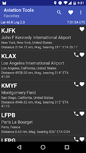
- Quickly find the nearest airports (displaying the distance and bearing)
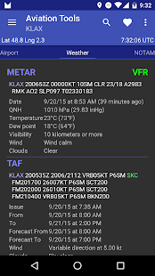
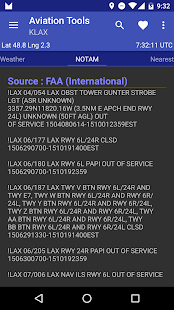
- Weather information and NOTAMs (remain available offline),
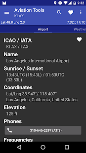
- Download directly all available documentations (AFD, TAKE-OFF MINIMUMS, ILS...)
- Call ATIS directly from the application,
- Calculate sunset and sunrise,
- Inline airport Editor to add or change an airport (collaborative)
- Worldwide database pre-loaded
- If you are not French use FAA source for NOTAMs (Note: go to menu Preferences and select "FAA")
- The METARs TAFs and are decoded and converted according to selected units in the "Preferences"
- And much more...
Feel free to contact me if you have problems or if you have ideas for new features or if you need a better support for your country.
If you want to make a donation and/or get rid of the ads, search for "Aviation Tools Donate" in the market.
Aviation Tools is a pilot tool for preparing flights.
Get instant access to useful informations : METARs, TAFs, NOTAMs, AFD ...
Available languages: English, French, German, Italian, Norwegian, Spanish
Danish, Portuguese
If you want to translate/correct :
http://www.getlocalization.com/aviatools/
Available Maps: USA, France, Italy (VATSIM), Netherlands, Norway, UK, Spain, South Africa
Contact to add more maps (I need a free website with PDF).
- Quickly find the nearest airports (displaying the distance and bearing)
- Weather information and NOTAMs (remain available offline),
- Download directly all available documentations (AFD, TAKE-OFF MINIMUMS, ILS...)
- Call ATIS directly from the application,
- Calculate sunset and sunrise,
- Inline airport Editor to add or change an airport (collaborative)
- Worldwide database pre-loaded
- If you are not French use FAA source for NOTAMs (Note: go to menu Preferences and select "FAA")
- The METARs TAFs and are decoded and converted according to selected units in the "Preferences"
- And much more...
Feel free to contact me if you have problems or if you have ideas for new features or if you need a better support for your country.
Celkové hodnocení
Sdílet
Souhrnné informace o Aviation Tools
-
Verze programu
2.3.7 -
Autor
-
Potřeba instalace
ano -
Velikost souboru
6,9 MB -
Jazyk
- Angličtina ,
- Francouzština
-
Staženo
1× celkem
0× tento měsíc -
Poslední aktualizace
30. 11. 2017