Wonderland Trail by Tami Asars
6.0.18
Wonderland Trail by Tami Asars
6.0.18
Wonderland Trail by Tami Asars is built through a collaboration of the creators of Guthook Guides hiking guide apps and Tami Asars, author of the popular guidebook "Hiking the Wonderland Trail: The Complete Guide to Mount Rainier's Premier Trail."
The Wonderland Trail app is a GPS- and map-based guide for your Wonderland Trail hiking experience.
NO MOBILE OR INTERNET service is required to use it after the initial setup.
Features:
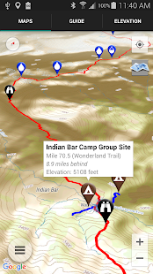
*GPS-enabled map of the Wonderland Trail and side trails
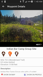
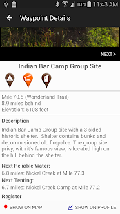
*400+ waypoints with over 500 photos
*Offline topo maps and satellite imagery.
*GPS-enabled elevation profile with waypoints
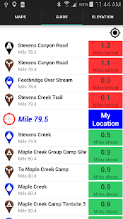
*GPS-enabled data book listing of all waypoints
The types of waypoints include:
-->Water sources (including the reliability of each water source)
-->Designated Wonderland Trail camping sites
-->Trail junctions
-->Parking areas
-->Ranger cabins
-->Road crossings
-->Natural landmarks
-->Privies
-->Views
About the Wonderland Trail: the Wonderland Trail is a 91-mile trail in Mount Rainier National Park (Washington state) that circumnavigates Mount Rainier.
The Wonderland Trail app is a GPS- and map-based guide for your Wonderland Trail hiking experience.
NO MOBILE OR INTERNET service is required to use it after the initial setup.
Features:
*GPS-enabled map of the Wonderland Trail and side trails
*400+ waypoints with over 500 photos
*Offline topo maps and satellite imagery.
*GPS-enabled elevation profile with waypoints
*GPS-enabled data book listing of all waypoints
The types of waypoints include:
-->Water sources (including the reliability of each water source)
-->Designated Wonderland Trail camping sites
-->Trail junctions
-->Parking areas
-->Ranger cabins
-->Road crossings
-->Natural landmarks
-->Privies
-->Views
About the Wonderland Trail: the Wonderland Trail is a 91-mile trail in Mount Rainier National Park (Washington state) that circumnavigates Mount Rainier.
Celkové hodnocení
Sdílet
Souhrnné informace o Wonderland Trail by Tami Asars
-
Verze programu
6.0.18 -
Autor
-
Potřeba instalace
ano -
Velikost souboru
6,7 MB -
Jazyk
- Angličtina
-
Staženo
0× celkem
0× tento měsíc -
Poslední aktualizace
2. 4. 2017