Contour lines plugin — OsmAnd
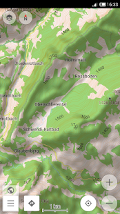
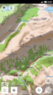
This plugin provides contour lines and hillshade which can be displayed in OsmAnd's offline maps.
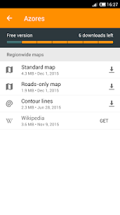
* To download hillshade and contour lines map: Manage map files → choose the country you need → Hillshade/Contour Lines
* To enable hillshade layer online maps plugin should be enabled and hillshade should be selected as underlay layer
* Latest update: download functionality is fixed (New OsmAnd is required) *
The global data (between 70 degrees north and 70 degrees south) is based on measurements by SRTM (Shuttle Radar Topography Mission) and ASTER (Advanced Spaceborne Thermal Emission and Reflection Radiometer), an imaging instrument onboard Terra, the flagship satellite of NASA's Earth Observing System. ASTER is a cooperative effort between NASA, Japan's Ministry of Economy, Trade and Industry (METI), and Japan Space Systems (J-spacesystems).
Celkové hodnocení
Sdílet
Souhrnné informace o Contour lines plugin — OsmAnd
-
Autor
-
Potřeba instalace
ano -
Velikost souboru
63 kB -
Jazyk
- Angličtina ,
- Francouzština ,
- Holandština ,
- Italština ,
- Němčina ,
- Polština ,
- Ruština ,
- Španělština
-
Staženo
0× celkem
0× tento měsíc -
Poslední aktualizace
27. 12. 2016